Test your skills as a historian of cartography...
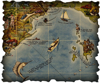
Or use this map of the Republic and Canal Zone of Panama to test your own map reading by clicking on the map to study the details that say a lot about the US authors' and audiences' interest in: nature, agriculture, leisure, colonial history, climate, tourism, trade, and more... As scholar JB Harley might say, the power of this map comes more clearly as you focus on the maps' elements--including illustrations, inset maps of the Canal Zone (large scale) and Panama at the heart of the Western Hemisphere (small scale), the band of flags around the border and the ships, planes, and other elements nestled in Caribbean & Pacific waters! What do those sailboats report on their billowing sails? Click on the map to take a closer look!

A Pictorial Map of the Republic of Panama with the Canal Zone.
Does the map look like a Google map of Panama today? Why or why not?

What's interesting about the map title?

What kind of features do you see in the map? Why does the mapmaker use sails to give us 3 different kinds of information? What is that information all about? What details are worth including in the legend, or key to the map? Do you need the legend to read the map?


What famous children's book character seems to be sitting on the map? Why would the mapmakers include it? How would you categorize the other details--what story of Panama do we learn from them?

 |
 |